B.
Christchurch 1850
Behind the scenes
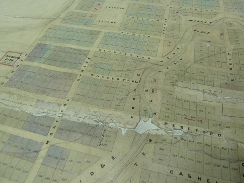
A carefully drawn plan on a sheet of paper: it's interesting to reflect that most cities didn't exist in this form before a single street had been formed, or hardly a building raised.
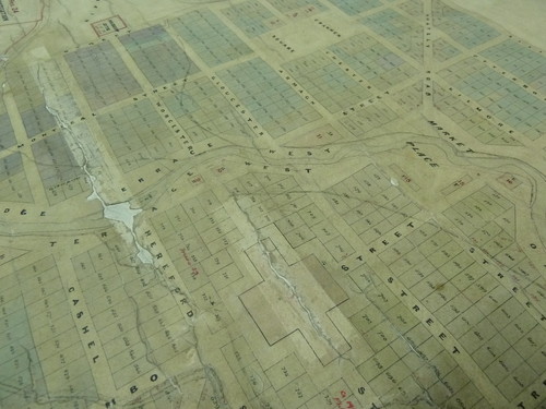
Edward Jollie, Black map 273, Plot of Christchurch, March 1850 (detail), 1850. Ink and watercolour. Archives New Zealand Christchurch Office CAYN 23142 CH1031 item 273/3
There's something different about a planned city. From the moment of its conception, or at least from the time of completion in March 1850 of young Edward Jollie's plan, the drawing remains a recognisable place.
Edward Jollie, Black map 273, Plot of Christchurch, March 1850 (detail), 1850. Ink and watercolour. Archives New Zealand Christchurch Office CAYN 23142 CH1031 item 273/3
It's not always ideal to be self-referential, but this particular flyover detail shows us something we've been reminded of a bit lately - the old tributary streams and springs over which the city was neatly laid. If you look closely and you'll find Te Puna o Waiwhetū.
The name Te Puna o Waiwhetū, loosely translated as 'water in which stars are reflected', refers to the artesian spring located on the Gallery site and the Waiwhetū stream which flows into the Avon River. - Gina Irish, Art New Zealand 108, 2003
Look again and you'll find Worcester Boulevard (though rather less grandly titled in March 1850 as plain old 'street').
Watch this space: Reconstruction: conversations on a city opening on 23 June between Montreal and Durham Streets.
Related
Exhibition
Reconstruction: Conversations on a City
23 June – 14 October 2012
In acknowledging architectural heritage loss in this city's present and past, this visually rich outdoor exhibition unfolds the ways in which dreams and values have been given form in our built environment.