Andreas Cellarius
Germany / Netherlands, b.c. 1596, d.1665 (Cartographer)
Jan van Loon
Netherlands, b.c. 1611, d.1686 (Engraver)
Tychonis Brahe Calculus, Planetarum Cursus Et Altitudines Ob Oculos Ponens
Tycho Brahe's Calculations, the Courses and Heights of the Planets, Confirmed by Observation
- 1660?
- Engraving
- William A. Sutton bequest, 2000
- 405 x 556mm
- 2000/83
Tags: cartouches (ornament), circles (plane figures), maps (documents), numbers, planets, putti (motifs), suns (stars), text (layout feature), words, zodiac symbols
Earth was still considered the centre of the universe when Dutch cartographer Andreas Cellarius first published his cosmographical atlas in 1660. This ancient belief is reflected in a chart outlining the hypothesis as understood by Hellenistic Greek scholar Claudius Ptolemy. Sixteenth-century Danish astronomer Tycho Brahe proposed that the Sun and Moon encircled the Earth, with other planets orbiting the Sun.
(Out of Time, 23 September 2023 – 28 April 2024)
Exhibition History
![Andreas Cellarius Hypothesis Ptolemaica Sive Communis Planetarum Motus Per Eccentricos Et Epicyclos Demonstrans [The Ptolemaic Hypothesis or Common Representation Demonstrating the Planetary Motions through Eccentrics and Epicycles] 1661. Hand-coloured engraving. Collection of Christchurch Art Gallery Te Puna o Waiwhetū, William A. Sutton bequest, 2000](/media/cache/05/97/05970cdff0f6b3264062d69bf2aa90f5.jpg)
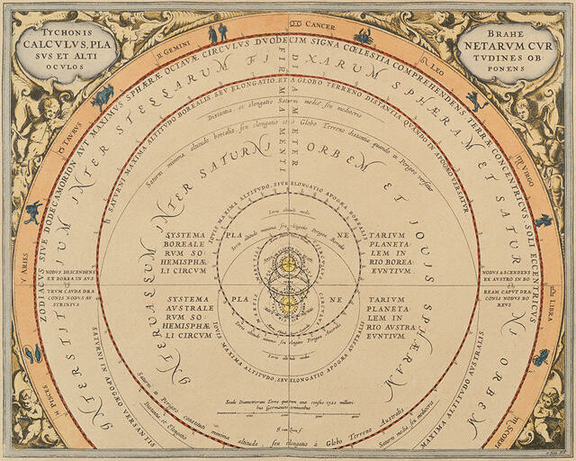
Andreas Cellarius’s best known work, the Harmonia Macrocosmica, was first published in 1660, and reprinted in 1661 and 1708. Intended as a cosmographical supplement to his Atlas Novus, it is regarded as one of the most spectacular cosmographical atlases of the period.
Born in Neuhausen (a small town near Worms, Germany) in around 1596, the son of a Protestant pastor, Andreas Cellarius enrolled at the University of Heidelberg in 1614. By 1625 he was employed as a schoolmaster in Amsterdam, and by 1630 at a Latin School in The Hague. In 1637 he moved to Hoorn (a town north-east of Amsterdam), to become rector of the Latin School at Hoorn, from where he produced several major scholarly works. Only 11 of the 30 illustrated plates in Harmonia Macrocosmica were signed by their engravers. This work was engraved by the Dutch mathematician, astronomer, chart maker and engraver Jan van Loon.
(Label date unknown)