Mark Adams
Aotearoa New Zealand, b.1949
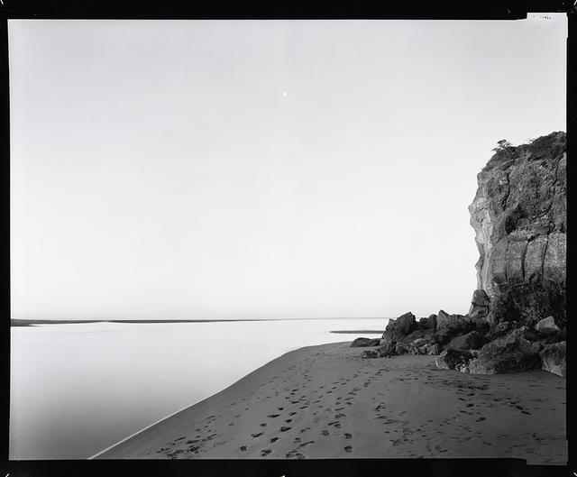
Rapanui [Shag Rock], Opawaho/Heathcote and Otakaro/Avon River Estuary, severely damaged in the earthquake of 22 Feb 2011. Photograph taken 25 August 1988, printed 2011.
- 2011
- Silver bromide photograph
- Purchased 2011
- 2011/234
- View on google maps
Tags: beaches, cliffs, footprints (foot impressions), horizon line, landscapes (representations), monochrome, natural landscapes, sand, seas
Rapanui, which in te reo Māori means ‘the great sternpost’, stood for thousands of years near Matuku-takotako Sumner, where the Ōpāwaho Heathcote and the Ōtākaro Avon rivers drain out to sea. Māori used the rock as a marker for passage into the estuary, an important mahika kai (food and resource gathering area) where Ngāi Tahu gathered shellfish, eels and harakeke. A naturally occurring seastack, known to many locals as Shag Rock, Rapanui was eight metres tall before the destructive earthquake of February 2011 reduced it to a heap half that high. Mark Adams’ photograph, taken twenty-three years earlier and reprinted following the earthquake, highlights that shocking transformation. It also calls attention to the many overlaid histories – human and natural – of this place.
(Absence, May 2023)
Exhibition History

Now, Then, Next: Time and the Contemporary, 15 June 2019 – 8 March 2020
Rapanui – Shag Rock, at Sumner – is one of the ancient landmarks of Te Waipounamu, the South Island. It stood for thousands of years in the estuary where the rivers that later came to be known as the Opawaho Heathcote and the Otakaro Avon drain out to sea, a traditional area of mahika kai (food and resource gathering) for Ngāi Tahu Māori. In the February 2011 earthquake, the rock pillar was reduced from its eight-metre stature to a shattered heap less than half that height. (In the black humour characteristic of Christchurch, some locals began referring to it instead as “shag pile”.) In 2011, Mark Adams reprinted a photograph he’d taken of the rock twenty-three years earlier, changing the title to acknowledge the effect of the earthquake. Adams’s photograph shows us the land as the repository of historic memory; the reprinted image stands as a contemporary meditation on loss and change that reaches beyond human history into geological time.