B.
THE ISLAND OF TOUI POENAMMU
Behind the scenes
I was fortunate enough to see first hand this stunning map of New Zealand's South Island / Te Waipounamu at the Mitchell Library in Sydney last week, a map which must rate as a very special taonga for Mainlanders.
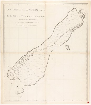
James Cook A CHART OF PART OF NEW ZEALAND OR THE ISLAND OF TOUI POENAMMU, 1770. Manuscript map Bequest of Sir William Dixson, 1952 DL SPENCER 166. Collection of the Mitchell Library, State Library of New South Wales.
You've got to hand it to Captain Cook, his chart, one of the first depicting Te Waipounamu, is a great effort and not far off a modern accurate map, a little narrow in the middle maybe with Stewart Island depicted as a peninsula and Banks Peninsula depicted as an island. What I like most about this map is the depiction of the Southern Alps / Ka Tiritiri o Te Moana, the mighty mountain chain that runs the length of the Island, depicted by Cook in this chart from Fiordland in the south to the Kaikoura Ranges on the upper east coast, it remains the defining feature of Te Waipounamu.